
Luther Cressman put UO archaeology on the map in 1938 with his discovery of 10,000-year-old sagebrush sandals in central Oregon. Today, UO archaeologists are finding evidence that the very first migrants to this continent may not have arrived on foot.
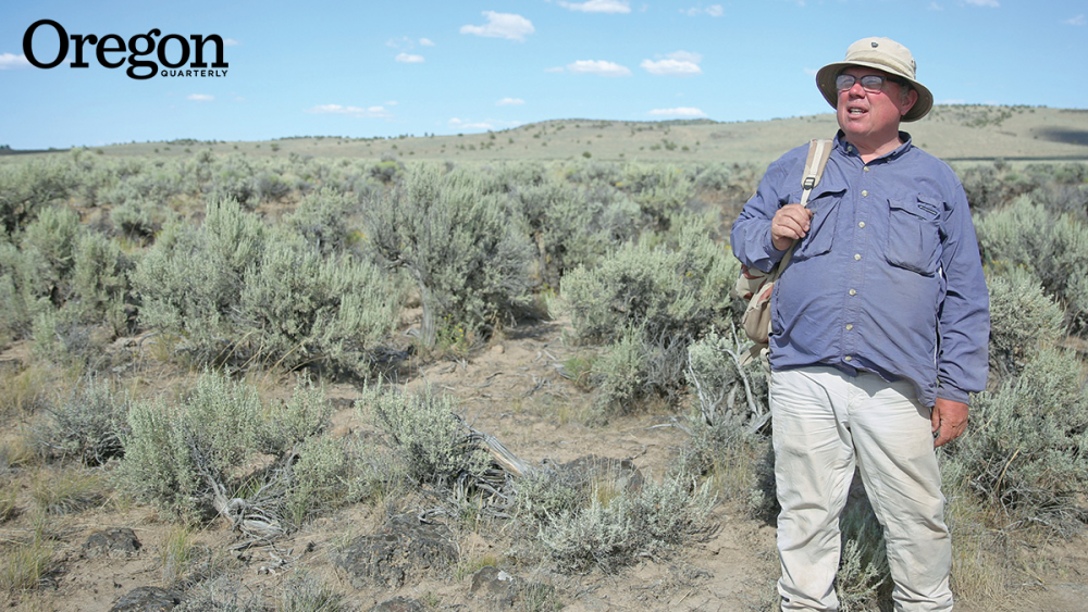
It’s the 11th hour of the last day of operations at the 2015 University of Oregon archaeology field school at Rimrock Draw Rockshelter, an area of tall basalt cliffs tucked into the rolling sagebrush-and-juniper country southwest of Burns, Oregon. Students have spent the morning winterizing the site, piling sandbags in the holes they spent the previous five-and-a-half weeks excavating. But not all are heaving sandbags—two diehards are still digging, taking turns excavating a few more centimeters of dirt in their assigned one-square-meter unit.
Susannah Philbrick, a junior at the College of William and Mary, has pretzeled herself into the bottom of the six-foot-deep hole and—with paintbrush, trowel, and artist’s palette knife—is clearing away the dirt, millimeter by millimeter, looking for artifacts as small as a fragment of charcoal, a burned rabbit bone, or a piece of human hair. She’s down so deep that she has to call out twice before Pat O’Grady, BS ’96, MS ’99, PhD ’06, staff archaeologist at the UO’s Museum of Natural and Cultural History, hears her.

“Pat? I found something you should come look at.”
It’s so dark and the “thing” is so dirt-caked that O’Grady has to scramble into the hole before he can identify it: a piece of translucent agate, the color of sunset and larger than a man’s thumb. One end has been crudely shaped and sharpened in a manner O’Grady recognizes as that of an “end scraper”—a tool used to abrade wood or clean an animal hide. It is strikingly similar to another orange agate tool—larger, its edges more finely crafted—that O’Grady found three years earlier just a few yards away. Both were buried below a thin layer of coarse volcanic fragments that geologists say spewed out of Mount St. Helens during an eruption about 15,000 years ago.
Someone, it seems, once used this scraper as part of life in Oregon’s Great Basin, not long after humans first painted in the caves at Lascaux, France, and just a few thousand years after people in China figured out how to make pottery. He or she must have dropped it or laid it on the ground one day. And no human touched it again until Philbrick plucked it from the dirt last summer.
BY LAND OR BY SEA
A charred seed, a bit of burned chokecherry, a sliver of tooth enamel from a camel, a sesamoid bone from a Bison antiquus, a spear point, knife, or scraper made of agate or obsidian, or—the prize of prizes—a lump of dried human feces: artifacts such as these, pulled from archaeological sites in Eastern Oregon by UO students and scientists, are helping rewrite the prehistory of this hemisphere.
The story you learned in school about fur-clad hunters making their way across the Bering Land Bridge at the end of the last Ice Age is not the story children will be reading a generation from now, after the textbooks are rewritten. Discoveries at inland sites from southern Chile to Fort Rock, Oregon, and among the islands and submerged coastal plains off the coasts of California and the Pacific Northwest, are pushing back the date when the first humans are thought to have arrived. These discoveries are causing archaeologists to reconsider the route these early settlers took on those first treks—or, perhaps more accurately, voyages.
To understand the new paradigm, one has to understand what it replaces. It was believed for most of the last century that toward the end of the Pleistocene epoch, not more than about 13,000 years ago, groups of humans migrated east from Siberia across Beringia. (The term “land bridge” doesn’t do justice to a vast subcontinent nearly 1,000 miles wide at its narrowest—an area of land exposed during the Last Glacial Maximum, when sea levels were almost 400 feet lower than they are today and massive ice sheets extended south beyond what is today the United States’ border with Canada.) Following woolly mammoths, mastodons, and other now-extinct big game, it was thought that these early explorers managed to squeeze through a hypothesized “ice-free corridor” in the vicinity of today’s British Columbia-Alberta border and, from there, ultimately dispersed throughout the hemisphere, all the way to the tip of South America.
What launched this theory were discoveries, in the 1920s and ’30s, of a particular type of spear point—large, with concave grooves, or fluting, for attaching to a spear shaft—first found in the vicinity of Clovis, New Mexico, and ever after known as Clovis points. Since then, Clovis points have been unearthed throughout most of the contiguous United States and as far south as northern South America. Clovis points and the culture they represent were ultimately dated to a period roughly 13,200 to 12,800 years ago—making them, at the time of their discovery, the oldest evidence of human occupation in what is now the Americas.

But was Clovis really first? Pioneer UO archaeologist Luther Cressman had his doubts. In 1939, one year after he made his groundbreaking discovery of 75 sagebrush sandals—later determined to be up to 10,500 years old—in Fort Rock Cave, he began investigating a site near Summer Lake, Oregon, known as Paisley Five Mile Point Caves. There he found well-preserved bones of extinct species of camel and horse alongside stone tools that looked nothing like Clovis points, leading him to speculate that people occupied Oregon’s Great Basin during the last Ice Age. But without good dating techniques and verifiable stratigraphy, the antiquity of his finds couldn’t be verified. In 1967 and 1968, Cressman’s last graduate student, Steve Bedwell, did some digging at a site called Connley Caves, about 30 miles from Paisley Caves, and found, among other things, projectile points that were narrower than Clovis points and lacking the fluting that characterized them. He estimated that these points, now called Western Stemmed points, were at least 13,000 years old. It appeared that people were in Oregon, hunting big game, at the same time or even earlier than Clovis people. But they may have been using a different type of spear point than that used elsewhere in North America.
But Bedwell was in a hurry, and in archaeology, without painstakingly tracking exactly what you find, at what depth, in relation to other things around it, you have nothing to hang your hat on. Stone tools can’t be radiocarbon dated; their estimated age is typically tied to the things they are found with, such as charcoal, bones, seeds, or other plant and animal remnants that can be dated. Bedwell’s discoveries were too haphazard to penetrate an archaeological community fully committed to Clovis First.
Then came Monte Verde. In the late 1990s, animal bones, hearths, scraps of clothing, and other evidence of human occupation were found at a site in southern Chile that was ultimately determined to be 1,000 years older than the oldest Clovis artifacts. It was an astounding discovery, and it would prove to be the beginning of the end of the Clovis First model.
PREDATING CLOVIS
Like archaeologists the world over, Dennis Jenkins, PhD ’91, had heard about Luther Cressman and his discoveries at the Paisley Caves. In 2001, Jenkins, senior staff archaeologist at the UO’s Museum of Natural and Cultural History, resolved to take another crack at the caves, hoping to find, identify, and date both Pleistocene animal bones and human artifacts. If the two overlapped, it would mean that people were there at the same time as the Pleistocene animals.
The discoveries were all that he had hoped for, including finding the proper sequence of projectile point types from the top to the bottom of the dig. He and his field school students found charcoal and burned bones. They found what appeared to be a garbage dump filled with horse, camel, and mountain sheep bones. Most exciting of all, they found coprolites: ancient human feces. Not the first human coprolites found in the Americas, but—as it turned out—the oldest. Radiocarbon dating indicates that this site was occupied by humans at least 14,400 years ago, which makes the Paisley Caves coprolites the oldest directly dated human remains in this hemisphere.

What’s so special about, as Jenkins sometimes calls it, “poo”? “You can reconstruct what people were eating,” he says. “You can get plant remains, fish scales, fish bones, small bones of rodents, insect parts if they were eating insects.” Anything that is not metabolized, he says, including pollen in the air, “comes out the other end.”
Pollen lets you know what species of plants were blooming in the vicinity. Parasites—like the thousands of hookworm eggs Jenkins found in several coprolites—reveal volumes about quality of life (“That person was listless and going to die the first time they got a cold,” he speculates). DNA found in the feces indicates who these cave dwellers descended from, what part of the world their ancestors came from, and who in today’s world may be descended from them.
“Paisley Caves is one of only about four sites in the Americas that are considered to be firmly dated as pre-Clovis,” says O’Grady. But soon, he adds with a hopeful smile, there may be another.
O’Grady learned field techniques as a student at Jenkins’s field school in 1994. Since 2000, he’s been running his own summer field school, and since 2012 it’s been at Rimrock Draw. To the untutored eye, the site doesn’t look like much: a slight fold in the arid, undulating landscape. But something about the place caught the eye of a friend, Bureau of Land Management archaeologist Scott Thomas, in the summer of 2009: unusually tall sagebrush that suggested a higher degree of moisture in the soil, and a dip in the land suggesting that a stream might once have run through here. In fall 2012—O’Grady’s second season at the site—his crew unearthed the orange agate tool from under a layer of 15,000-year-old volcanic tephra.
One apparently very old tool does not a confirmed pre-Clovis site make, as O’Grady is quick to point out. But with the second agate tool found in 2015—and a host of other artifacts of apparently similar vintage—he’s hoping to build an airtight case. He’s eager to return to Rimrock Draw next summer to see what else might lie buried in dirt at the same depth, just a few feet away.
THE KELP HIGHWAY
So if humans have been in Oregon’s Great Basin for at least 14,000 years, and if they came from northeast Asia, as DNA found in the Paisley Caves coprolites seems to suggest, what route did the first migrants take? Through Beringia and south through the fabled ice-free corridor?
Not likely, says archaeology professor Jon Erlandson, director of the UO Museum of Natural and Cultural History. An “ice-free corridor” wouldn’t have opened up in time for people to get to Oregon 14,500 years ago. The variations found among spear point technologies and other artifacts found across North America suggest that people came here in waves, following a variety of routes, he says. But the very first migration probably happened not overland, but by boat, following what Erlandson calls the “kelp highway”—the resource-rich, near-shore North Pacific Ocean.
As recently as 10 or 15 years ago, Erlandson’s was a lonely position. “Invariably at conferences there would be nine people talking about the land bridge and the Clovis people, and they’d throw in one coastal person just to be representative, and that’s who I was. Nowadays, if you took a poll of 10 presenters at a conference, asking how people first got to the Americas, probably nine of them would say ‘coastal migration.’”

As archaeological evidence of pre-Clovis migration into North America has accumulated, so has geological research suggesting that Beringia and the interior of Canada were too cold 15,000 years ago to support human communities. Meanwhile, the Pacific Northwest coast wasn’t as inhospitable as was once thought; there were almost certainly gaps in the glaciers where people could come ashore to hunt land mammals and get fresh water. And the coastal glaciers retreated earlier than those inland. Besides, Australia had been colonized by seafarers from Asia at least 40,000 years ago. Clearly, humans had figured out how to build and handle boats and had even undertaken long ocean crossings well before they first ventured toward the Americas.
The trouble is, there’s scant evidence of ancient humans along the coast. And for good reason: Places where the earliest people would have camped, even settled, along the shore have long since been inundated by seas rising after the Last Glacial Maximum (the period in Earth’s history, about 25,000 years ago, when the glaciers were at their thickest and the sea levels at their lowest). Evidence of ancient hearths with their charcoal and charred bones, middens and piles of animal bones, certainly coprolites: all would have long since decomposed in the ocean or been scattered by the waves.
But not stone tools. In upland sites in California’s Channel Islands, Erlandson has found hundreds of delicate stemmed points (not Clovis points) in sites dated 12,000 years old or older, sites where coastal dwellers might have gone to keep watch on the shoreline and, while there, do some flint-knapping, replenishing their hunting arsenal. Stone tools are what Erlandson is most likely to find this year as he and his colleagues launch an ambitious four-year, $900,000 project funded by the Bureau of Ocean Energy Management to map, model, and explore submerged landscapes off the northern Channel Islands and the Oregon coast. Among the first activities: exploration of the strait between two of the Channel Islands to look for evidence of human occupation 9,000 years ago, when the two islands were one and the strait was a bay. In October, Erlandson made four dives in a two-person submarine to as much as 300 feet deep, exploring the margins of a submarine canyon that may have attracted early islanders.
It may seem like a long shot. But in 2014, after carefully mapping the seafloor with high-resolution imaging, a team of British Columbian researchers using a robotic underwater vehicle identified what appeared to be a stone weir—a fish trap, the kind used for generations to catch migrating salmon—in the ocean off the southern coast of the Haida Gwaii archipelago (the Queen Charlotte Islands, north of Vancouver Island). Today the weir is deep under Hecate Strait, but 13,800 years ago its stone pickets would have fenced the mouth of a stream entering a river that flowed across the coastal plain, possibly in sight of a settlement.
A DEVELOPING STORY
Jenkins, meanwhile, has turned his attention to Connley Caves, the site investigated by Steve Bedwell in the 1960s. He began working there in 2014 doing—as he puts it—the “archaeology of archaeology”—reexamining the soil disturbed by Bedwell’s digging. This past summer he went deeper, into previously undisturbed soil, and found 18 projectile points, 45 scrapers, 51 flake knives and scrapers, and two incredibly delicate bone needles determined, with radiocarbon dating, to be between 12,000 and nearly 13,000 years old. He plans to return to Connley Caves in the summer of 2016, this time searching for artifacts in nearby areas never touched by Bedwell.
But he doesn’t plan to return to Paisley Caves. “I know that there are wonderful deposits still there,” he says, “and I’m going to leave them right there for the future.” A future archaeologist, he means—perhaps one of his own students, using tools and techniques, in the field and the lab, still in development or even beyond the imagination of today’s scientists.
“We’re in an archaeology frontier right now in Oregon,” O’Grady says. “We have some solid dates with Paisley, and I’m starting to make some progress on these possible pre-Clovis sites that will tell us some interesting things here in the near future, and we have Erlandson’s work on the coast that suggests that people were coming here by boat.
“But right now, here in Oregon, we’re just starting to get a sense of what the story looks like. It’s still a very developing story.”
“It’s a really interesting time,” echoes Erlandson. “Much of what I learned in graduate school was wrong. It’s wonderful!”
—By Bonnie Henderson
Bonnie Henderson, BA ’79, MA ’85, is the author of, most recently, The Next Tsunami: Living on a Restless Coast.
HEAD OF THE CLASS

Of the four grad students accepted this year by Texas A&M University’s Center for the Study of the First Americans, considered the preeminent institute dedicated to advancing understanding of human migration into the Americas, two are graduates of UO’s archaeology program. Katelyn McDonough, a supervisor at Jenkins’s Connley Caves field school for the past two summers, plans to continue work in the Great Basin, particularly on pollen and parasite analysis of coprolites. Jordan Pratt (left), a supervisor at O’Grady’s field school for two years, hopes to research shifts in mobility and settlement patterns in the Great Basin in relation to climate change. Two out of four—as O’Grady points out, “That’s pretty good shootin’.”